Pasco's new golf cart rules are in force, and the county's map lists about 26 miles of Wesley Chapel streets. Most of the county's approved cart trails are here too.
Pasco County’s new golf cart rules are now in force. The county’s online map shows about 26 miles of Wesley Chapel streets where carts are allowed, by our measurement of the map’s data.
County commissioners approved both parts of the package on Oct. 20, according to the clerk’s annotated agenda for the meeting. They adopted the trail ordinance, item P31, by a roll call vote. They also approved the road resolution, item R28. We previewed both items before the vote.
The trail ordinance is Ordinance 26-39. It took effect when it was filed with the Florida Department of State. The state acknowledged the filing on Oct. 21, according to the copy of the ordinance the county has posted.
What the map shows for Wesley Chapel
The county’s Golf Cart Regulations page now links to a Golf Cart Network Map. It shows every road and trail where carts are approved in unincorporated Pasco.
We measured the approved streets in the map’s data on Saturday. The streets labeled Wesley Chapel add up to about 26 miles:
- Watergrass: about 7 miles of neighborhood streets
- Epperson Ranch: about 6 miles, including parts of Epperson Boulevard
- Other Wesley Chapel streets: about 13 miles, including Connected City Way, Dynamic Boulevard and Innovation Spring Boulevard, and stretches of Elam Road, McKendree Road and Ruben Barnes Road
Our neighborhood guides cover Watergrass and Epperson.
Most of the county’s cart trails are here
The map shows about 11 miles of paved trail approved for golf carts across Pasco County. Almost all of it, about 10.9 miles, is in and around Wesley Chapel. The longest stretches run beside:
| Trail along | Approx. miles |
|---|---|
| Watergrass Parkway | 1.9 |
| Curley Road | 1.7 |
| Overpass Road | 1.5 |
| Old Bridge Road | 1.1 |
| Mirada Boulevard | 0.7 |
| Elam Road | 0.7 |
The rest are short links and crossings, many under a tenth of a mile.
How Wesley Chapel compares
Countywide, the map lists about 336 miles of approved roads. Grouped by the map’s own city labels, which follow mailing addresses, the largest areas are:
- New Port Richey: about 103 miles
- San Antonio: about 58 miles
- Zephyrhills: about 46 miles
- Hudson: about 30 miles
- Wesley Chapel: about 26 miles
- Dade City: about 17 miles
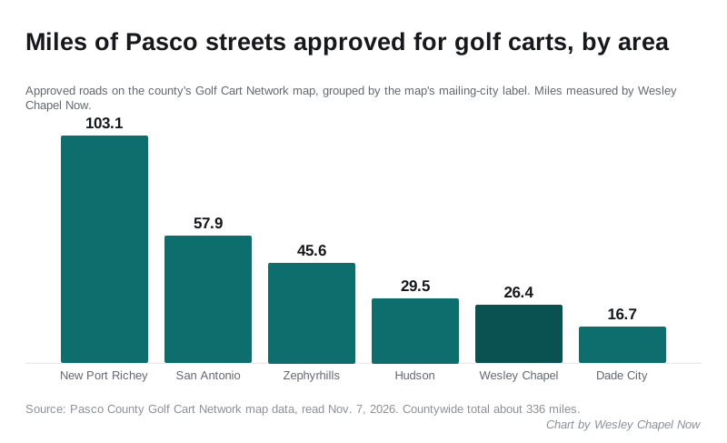
These are our measurements of the county’s map lines, rounded. They are a guide to scale. The map itself is the record of which streets are approved.
The rules now in force
The county’s regulations page sets out the rules for drivers:
- carts may go no faster than 15 mph on trails
- carts must yield to people walking and cycling
- drivers 18 or older need a valid government-issued photo ID
- drivers under 18 need a learner’s permit or a driver’s license
Every cart needs brakes, steering, safe tires, a rearview mirror and red reflectors front and back. After sunset it also needs headlights, brake lights, turn signals and a windshield.
Carts are allowed only on the trails the county has approved. The county says approvals may be revoked if safety concerns arise.
How a neighborhood gets added
A community that wants carts on its roads or trails fills out the county’s application. It goes, with the required attachments, to the county at DAS@MyPasco.net.
To qualify, a road must:
- not be an arterial road
- have a speed limit of 30 mph or less
- carry no more than 5,000 vehicles a day
- have no more than 10% truck traffic
A trail must be paved at least 10 feet wide, with at least 15 feet of clearance. Crossing a state highway needs approval from the Florida Department of Transportation. Crossing a county arterial or collector road needs the county engineer’s approval.
What it means for you
- Check your street before you drive a cart on it. Search your address on the Golf Cart Network Map. If it is not shown, it is not approved.
- Stay off trails the map does not show. The new ordinance bans carts on unapproved trails, except as a mobility device under federal disability rules.
- Want your neighborhood added? Ask your HOA or CDD board. Under the county’s process, the community applies, not individual residents.
- Private streets and parking lots are not covered. The county says cart use there is up to the association or the property owner.
- Planning a trip? Check which roads are closed first.
Have your say